Our Most Popular Handheld GPS Made Even Better
- Worldwide basemap
- 2.2" 65K color, sunlight-readable display
- GPS and GLONASS satellites for faster positioning
- Paperless geocaching
- 25-hour battery life with 2 AA batteries
eTrex 20 takes one of the most popular and reliable GPS
handhelds and makes it better. Redesigned ergonomics, an easier-to-use
interface, paperless geocaching and expanded mapping capabilities add up
to serious improvements for an already legendary GPS handheld. eTrex 20
is versatile. It's tough. And it’s built to handle whatever Mother
Nature can dish out – and more.
See The Way
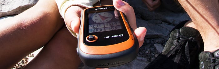
eTrex 20 has an enhanced 2.2 in 65K colour, sunlight readable
display. Durable and waterproof, eTrex 20 is built to withstand the
elements. It has an upgraded interface yet retains its legendary
toughness to withstand the elements – be it dust, dirt, humidity or
water, none of which are a match for this storied navigator.
Go Anywhere
With an array of compatible mounts, eTrex 20 is designed for use on
ATV’s, bicycles, in boats, as a handheld or in your car. Use the auto
mount capability and
City Navigator Australia & New Zealand NT
maps for turn-by-turn driving directions, or the rugged mount for your
motorcycle or ATV. Wherever you think you might take eTrex, it has the
mapping and mounts to get you there.
Go Global
The new eTrex series is the first-ever consumer-grade receivers that
can track both GPS and GLONASS satellites simultaneously. GLONASS is a
system developed by the Russian Federation that will be fully
operational in 2012. When using GLONASS satellites, the time it takes
for the receiver to “lock on” to a position is (on average)
approximately 20 percent faster than using GPS. And when using both GPS
and GLONASS, the receiver has the ability to lock on to 24 more
satellites than using GPS alone.
Add Maps
With its microSD™ card slot and 1.7 GB of internal memory, eTrex 20 lets you load
BlueChart® g2 preloaded cards for a great day on the water or
City Navigator Australia & New Zealand NT® map data for turn-by-turn routing on roads (see maps tab for compatible maps). eTrex 20 also supports
BirdsEye ™
Satellite Imagery (subscription required), that lets you download
satellite images to your device and integrate them with your maps.
Keep Your Fix
With its high-sensitivity, WAAS-enabled GPS receiver and HotFix®
satellite prediction, eTrex locates your position quickly and precisely
and maintains its GPS location even in heavy cover and deep canyons.
Find Fun
eTrex 20 supports
geocaching GPX files for downloading geocaches and details straight to your unit. Visit
OpenCaching.com
to start your geocaching adventure. By going paperless, you're not only
helping the environment but also improving efficiency. eTrex 20 stores
and displays key information, including location, terrain, difficulty,
hints and descriptions, which means no more manually entering
coordinates and paper print outs. Simply upload the GPX file to your
unit and start hunting for caches.


 Download Brosur:
 tlp
tlp  sms
sms  wa
wa  tg
tg  e-m
e-m